3D modelling for better planning
8 April 2020
SHARE

Advancement in computer software and hardware technologies is causing a sea change in the way local governments are using 3D modelling for planning and designing future developments. Two-dimensional representation of alternative scenarios is a thing of the past, writes GIS specialist Sandeep Gangar.
Though more traditional ‘illustrations’ have served us well, some find it challenging to visualise a scenario in 3D by looking at a flat 2D rendering. Would a tall, proposed building affect the skyline? What is the maximum achievable height on a parcel under the planning rules? The answer to these rules can be simple, but what if there are multiple restrictions – like a viewshaft, or a height in relation to boundary, or sunlight controls in Auckland’s City Centre? Local government are increasingly using detailed and visually appealing 3D models for determining these answers and improving the outcomes of their planning processes.
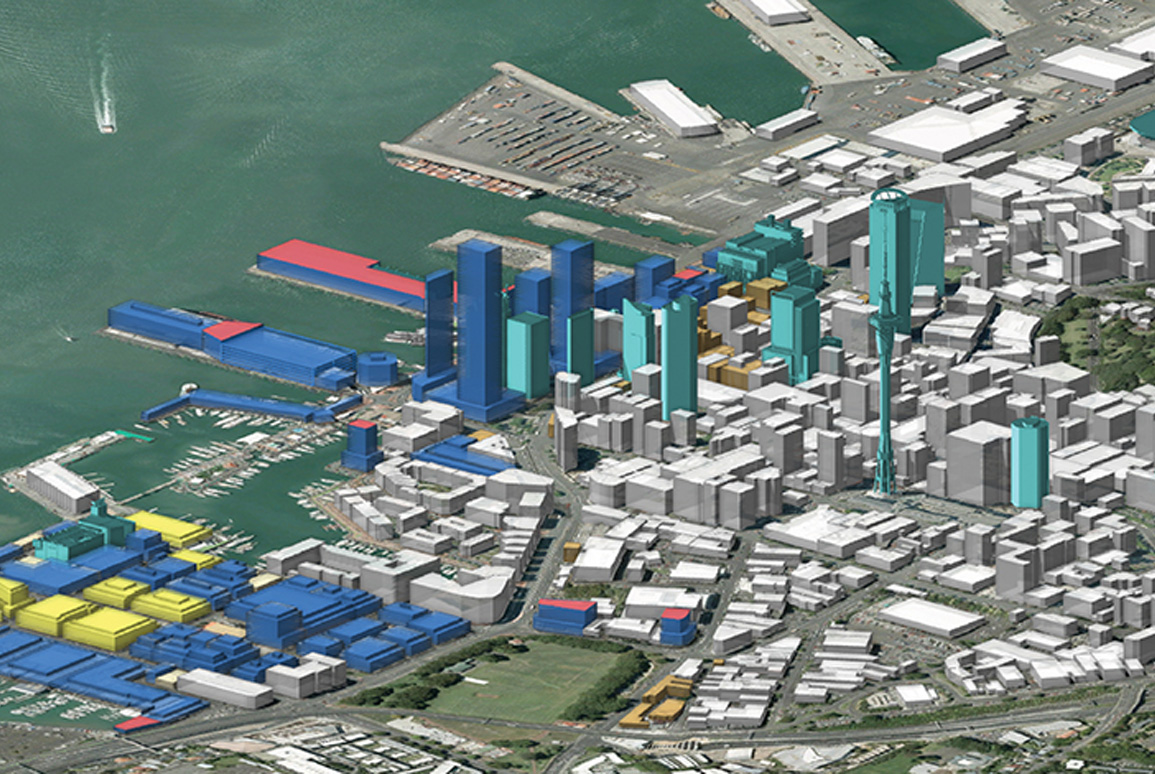
One of the earliest 3D models Boffa Miskell developed was for Auckland Council – to help them with the early development of the Draft Auckland Unitary Plan process. Developed in CityEngine, this was an exercise of interpreting the potential planning rules applicable in the City Centre and applying them on a section along the waterfront and Wynyard Precinct. Sensitivity testing was undertaken on rules like Floor Area Ratio (FAR), setbacks, height restrictions, viewshafts and sunlight controls that were applied to the land parcels. The objective of this exercise was to assist Council planners in considering potential changes to building height and associated controls across the waterfront precincts. The modelling enabled rapid testing and analysis of planning rules through accurate representations of the urban form that was likely to result from the Unitary Plan Rules.
This dynamic model allowed users to modify the rules in real time and instantly see the changes to the massing and height of buildings. Using this model, planners at Auckland Council could weigh the pros and cons of the alternative scenarios in an interactive environment. A key benefit of this model was the ability to evaluate the submissions Council had received seeking additional building heights and changes to the planning rules. Waterfront Auckland (now Panuku Development Auckland) also utilised this model for Visual Assessment and Urban Design Assessment of some of their own proposals in the Wynyard Precinct.
“The use of CityEngine for this planning study proved invaluable, enabling rapid and robust modelling and analysis of different scenarios to feed into the early development of a complex set of planning provisions”, says Stuart Houghton, Landscape Architect at Boffa Miskell.
Visualising proposals in 3D is important; but it is just one of the capabilities provided by modelling software today. A sophisticated software like CityEngine also offers the ability to determine the development potential of sites and places in urban areas. Auckland Transport sought Boffa Miskell’s help in determining the permissible development potential of several properties located on the Central Rail Link (CRL). Applying the zoning rules and presenting the built form of each property in 3D, allowed our planners to prepare a detailed assessment of each site. This information would enable the Auckland Transport team to commence negotiations with landowners in acquiring the subterranean portion of their landholdings required for construction, operation and maintenance of the tunnel.
The aim of an analyst when creating a 3D model is to produce a representation of earth’s surface with a high degree of accuracy so that the potential scenarios, when placed in the model can provide an accurate representation of the landscape. Availability of accurate LiDAR makes this possible and the raw point cloud data provides an excellent representation of the above ground features as a set of points. This opens a world of opportunities for landscape representation on a variety of projects.
“Evaluating landscape and visual effects of new developments is a key requirement of the resource management decision-making process. We rely a lot on undertaking visibility analyses (using Zone of Theoretical Visibility technology) and preparing visual simulations to support our written assessment reports. The new 3D modelling methods add a new tool to our arsenal. Using accurate terrain and point cloud data, we can navigate through a 3D model to view a proposal and take screenshots from as many locations as is necessary. This helps us when we liaise with Council’s experts, to support our assessment evaluations and when giving evidence in the Environment Court. 3D modelling helps us assess how a new development can be better integrated into its landscape setting and determine appropriate mitigation measures to achieve a better environmental outcome”, says John Goodwin, Landscape Architect and Partner at Boffa Miskell.
Visualising future scenarios in its local and regional context enables a deeper understanding of how the proposal will change the area. 3D models can be shared over the internet making it easier for the public and other stakeholders to provide feedback and have an influence on a proposed development. It is easier to see the benefit in an urban setting, but 3D modelling becomes even more important when working in sensitive areas or rural areas that are difficult to traverse.
“The visual models we have developed have helped us immensely when working on sensitive sites such as Waikeria Prison. We can assess the effects of proposed structures on the surrounding environment from several vantage points without having to access these locations directly. The ability to navigate through the model means we can select the most representative views, and these can be quickly updated if there is a change in plans as the project evolves. In other cases, we have used this technology to demonstrate to Council that neighbours to a site will not be affected visually by a proposed development because intervening landforms or vegetation means it won’t be visible”, says Sharon Dines, Senior Planner at Boffa Miskell.
The tools available for 3D modelling are evolving rapidly. A seamless interaction allows for an easy conversion of 3D models to gaming engines like Unreal and Unity. Virtual environments are being created of potential scenarios where a person can navigate using a ‘First Person’ view, getting a real sense of a new proposal.
GIS software like ArcGIS Pro and CityEngine include interactive tools for conducting visibility analysis, in near real-time.
Local governments are increasingly seeing the benefit that these new tools are offering in urban and regional planning. Showcasing proposals in 3D and in context of their environment has the potential of making public engagement more meaningful, creating a sense of transparency and trust between the local government and the public. It seems we are at the cusp of a visualisation revolution. Creating interactive, dynamic, living and evolving 3D models is the way forward in our quest of having better outcomes of our planning processes.
(Note: This article was originally published in the April 2020 issue of Local Government Magazine).
For further information please contact Sandeep Gangar